People Who Called Scarborough Home
By Charlene Fenlason
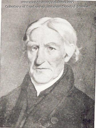
Henry Jocelyn

Map – Black Point, Scarborough, c. 1741
Henry Jocelyn, son of Sir Thomas Jocelyn and his second wife Theodora Cooke, was born in England in 1606. He was educated at Cambridge, receiving his degree in 1623; and by 1630, he was living in New England. Probably at the request of Gorges, Jocelyn joined his friend Cammock and wife Margaret at Black Point in 1635. Cammock and Jocelyn had known each other at Piscataqua where Cammock had been an agent of Gorges and Mason until he assumed proprietorship of his 1500-acre Black Point Patent in 1633. On a voyage to the West Indies in 1643, Cammock died, leaving his estate to his wife for her lifetime and then to his friend Jocelyn. In the same year, Jocelyn married the widow Margaret and came into possession of Cammock’s property. For nearly forty years Jocelyn was a prominent leader in the area. By 1671 Jocelyn found his business interests less profitable than in the early days of his proprietorship and he mortgaged his holdings to Joshua Scottow. Jocelyn remained at Black Point as a manager and supervised the construction of a garrison on the west side of Black Point. In 1676 Mogg Heigon and his men led an unsuccessful attack on the Black Point garrison. Mogg suggested to Jocelyn that the settlers in the garrison could safely leave the garrison if it were surrendered to him. When Jocelyn returned to the garrison, all had left but his family. Jocelyn then surrendered the garrison and was briefly held captive, but he never returned to Black Point. He died before May 1683.
Sources
Moulton, Augustus. Grandfather Tales of Scarborough. Portland, ME: Katahdin Publishing Co., 1925.
Moulton, Augustus. Old Prouts Neck. Portland, ME: Marks Printing House, 1924.