Scarborough History Overview

By Don Taylor

Scarborough, Maine, located along the southern coast of Cumberland County about seven miles south of Portland, is one of the earliest English settlements in the region. With a landscape shaped by rivers, marshes, and a long stretch of coastline along Saco Bay, Scarborough’s history reflects the interaction of Native peoples, early European settlers, maritime commerce, agriculture, and modern suburban growth.

Indigenous Land: Owascoag

Aerial view of Scarborough Marsh showing the extensive tidal marshlands and waterways that shaped early settlement in Scarborough, Maine.
Scarborough Marsh, the largest salt marsh in Maine, has shaped the town’s history for centuries. Native peoples called the region Owascoag, meaning “land of much grass.”

Long before European settlement, the area now known as Scarborough was inhabited by Native peoples of the Sokokis or related Abenaki groups. They called the region Owascoag, meaning “land of much grass,” a reference to the extensive tidal marshes that dominate the landscape. These marshes provided fish, shellfish, and wildlife, which formed an important food source and trading commodity. Archaeological evidence such as shell middens and remnants of fish weirs along the marsh rivers testify to this early presence. 

Early European Settlement

Historic map of Black Point in Scarborough, Maine, one of the earliest English settlement areas in the town.
Map of Black Point in the Province of Maine. Captain Thomas Cammock established a plantation here in the 1630s under the Black Point Patent.

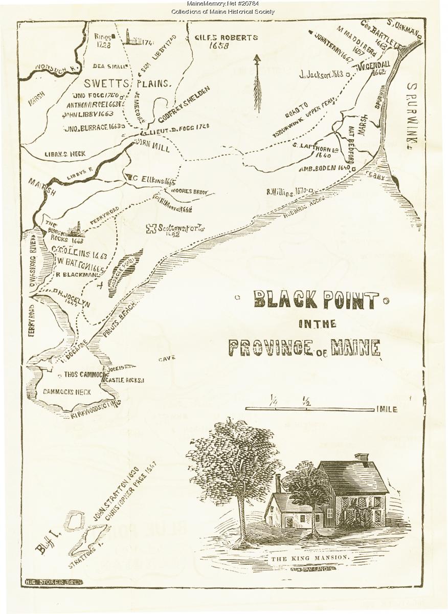
The first known European activity in the area occurred around 1630, when John Stratton established a trading and fishing station on islands off the coast of present-day Scarborough. These islands were soon known as Stratton’s Plantation. In 1631, Captain Thomas Cammock received the “Black Point Patent” from the Plymouth Council for New England, granting him a large tract of land stretching from the Spurwink River to Black Point (now Prouts Neck). Cammock settled there around 1635, beginning what would become a permanent English presence in the area. 

Additional settlements soon developed at Black Point, Blue Point (Pine Point), Dunstan, and Stratton Island, supported by fishing, farming, and trade. By about 1650, the community had grown to approximately fifty homes. Recognizing its importance, the Massachusetts General Court formally incorporated the town of Scarborough on July 14, 1658, naming it after Scarborough in Yorkshire, England. 

Conflict and Abandonment

Hunnewell House, ca. 1950
The Hunnewell House (ca. 1950) is believed to date from around 1702, is among the oldest surviving buildings in Scarborough, and reflects the early resettlement period after the colonial wars.

Life on the Maine frontier was precarious. During King Philip’s War (1675–1678), Scarborough became a focal point of conflict between English settlers and Native forces. The settlement suffered devastating attacks in 1676, leaving the town largely destroyed. In a notable engagement known as the Battle of Moore’s Brook in 1677, a Massachusetts militia force was ambushed near Black Point, resulting in heavy casualties. 

Although the town attempted to rebuild and constructed a large fort at Black Point in 1681, continuing conflicts during later colonial wars forced the settlers to abandon the town in 1690 and seek safety in Portsmouth and Boston. 

Resettlement and Growth

Historic view of hay wagon at the Nonesuch Farm in Scarborough. It Illustrating the agricultural landscape of the town in the late nineteenth century.
Agriculture dominated Scarborough’s economy through the eighteenth and nineteenth centuries. Farms such as Nonesuch supplied hay, dairy products, and livestock to the region.

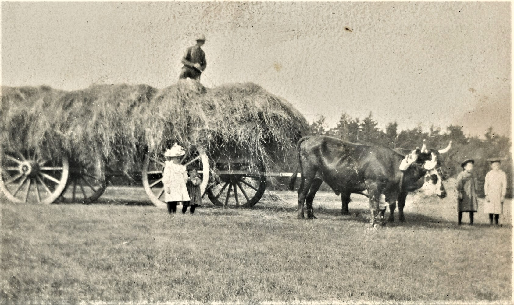
Scarborough was resettled beginning in 1702, when new settlers from Massachusetts established homes and built another defensive fort at Prouts Neck. Over the next several decades, the community gradually stabilized and expanded. By the mid-18th century, Scarborough was again a prosperous settlement, exporting timber, cattle, and agricultural products, and operating numerous water-powered sawmills along its rivers. 

During the 18th and 19th centuries, farming became the dominant economic activity. The town’s fertile soils supported crops and livestock, while the coastline and rivers provided fishing and small-scale maritime commerce. Dunstan Landing briefly served as a small port and shipbuilding location, though Scarborough never developed the extensive shipbuilding industry seen in nearby coastal towns. 

Geography and Natural Landscape

Photograph of clam diggers working on the tidal flats near Pine Point in Scarborough.
Scarborough’s tidal flats and coastal waters supported fishing, clamming, and maritime trades for generations of residents

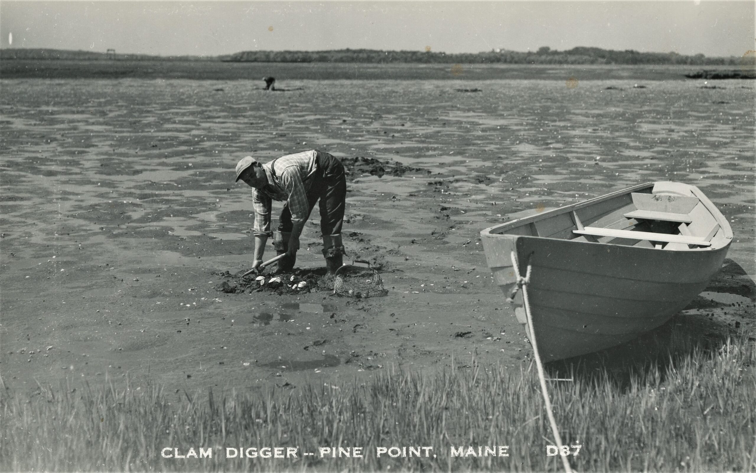
Scarborough’s geography has always shaped its history. The town encompasses roughly 50 square miles and includes thirteen historic neighborhoods such as Black Point, Blue Point, Dunstan, Pine Point, Higgins Beach, and Pleasant Hill. The town’s rivers—including the Spurwink, Nonesuch, and Dunstan—feed into the Scarborough Marsh, the largest continuous tidal marsh in Maine. 

These wetlands historically supported fishing, agriculture, and wildlife, and today they remain an important ecological and conservation area.

Twentieth Century Development

During the late nineteenth and twentieth centuries, Scarborough evolved from a rural agricultural town into a community with increasing recreational and residential appeal. Coastal areas such as Prouts Neck and Higgins Beach developed as summer destinations, attracting artists, writers, and vacationers. The construction of modern transportation routes and Scarborough’s proximity to Portland accelerated residential growth in the late twentieth century.

Scarborough Today

Photo of the Winslow Homer Studio at Prouts Neck in Scarborough, Maine,
The Winslow Homer Studio at Prouts Neck commemorates the famous American artist who lived and painted there from 1884 to 1910.

Today, Scarborough is one of the larger and fastest-growing communities in southern Maine, with approximately 20,000 residents. The town maintains a strong connection to its past through preserved historic structures, archaeological sites, and local institutions such as the Scarborough Historical Society, which collects, preserves, and interprets the town’s history. 

Scarborough’s long history—from its Indigenous origins and early colonial settlement through periods of conflict, rebuilding, agricultural development, and modern growth—illustrates the resilience and adaptability of coastal Maine communities.

Learn More

Visitors interested in learning more about Scarborough’s history are encouraged to visit the Scarborough Historical Society Museum, located in the former Portland Railroad Company Substation, and explore the Society’s archives and exhibits.


Disclaimer: This article was researched and written by the author. ChatGPT was used as a research and drafting aid, and Grammarly was used for editorial review and copy editing.

Posted in Agriculture, Historic, History, Places, Scarborough History | Tagged , , , , , , , , , , , , , , , , , , , , , , | Leave a comment

Updates – February 2026

Education

High Schools – The New High School – 1927

Class of 1931

Commencement Program – SHS – Class of 1931.

Posted in Uncategorized | Comments Off on Updates – February 2026

January 2026 Presentation Now Available

“‘Nimrod the Scarboro Slave’ and Other Stories about Slavery in Maine” by Eben Miller

Recorded January 4, 2026, at the Scarborough Historical Society’s monthly meeting, “‘Nimrod the Scarboro Slave’ and Other Stories about Slavery in Maine.” Presented by Eben Miller, this presentation draws on local traditions, such as stories like “Nimrod the Scarboro Slave,” as well as archival resources to explore the history of slavery in Scarborough and elsewhere in Maine.

Watch all of our videos through our SHS Videos page.

Posted in Uncategorized | Comments Off on January 2026 Presentation Now Available

Updates November 2025

Articles/Posts

Preserving History:The Blue Point Church Bell Finds a New Home

The historic bell from the 1878 Blue Point Congregational Church has been restored and relocated beside Alger Hall. Thanks to Eagle Scout Ben Kildow’s leadership, the bell now rests under a new protective shelter, preserving its legacy as a proud symbol of Scarborough’s faith, history, and enduring community spirit for generations to come.


Library

Videos

Nov 2025 – Water in Scarborough

Due to unforeseen personnel and technical difficulties, we were unable to record Paul Thomas Hunt’s presentation, “Water in Scarborough.” Fortunately, Mr. Hunt gave a similar talk to another group in May, which covered much of the same material. In addition to discussing the water supplied by the Portland Water District (PWD), that earlier presentation also addressed wastewater collection and treatment managed by the PWD.

1200 Miles of Pipe
A History of Water and Wastewater in Greater Portland

Posted in Churches, Videos | Comments Off on Updates November 2025

Sorting Letters at the Cemetery

by Ron Romano

While poking around Dunstan Cemetery recently I noticed that Millard Whitten’s grave has a small metal decorative stake featuring an eagle and some unfamiliar letters. Its banner reads “IMP’D  O.R.M.,” and the shield reads “T.O.T.E.” Searching online I quickly learned what those letters meant. Millard was a member of a fraternal organization known as the Improved Order of Red Men. Members of the I.O.R.M. had a secret password, TOTE (for “Totem of the Eagles”), though the secret seems to be out since it was prominently shown at his grave!

Image of a sone eagle with the letters IMP'D O.R.M. above and a shield over the T.O.T.E.
Decorative metal stake at
Millard Whitten’s gravestone.

During Millard’s life (1869-1925) hundreds of fraternal organizations existed. Quite popular in Maine were the Masons, the Odd Fellows, and the Knights of Pythias, each serving as social and charitable groups. They limited their membership to white men—from the middle and upper classes—though a few offered women membership in auxiliary groups. Each had its own rules and practices, uniforms and regalia, mottos and symbols, and initials. Symbols and initials were used on flags and printed materials, but also occasionally adorned members’ gravestones. We find them carved onto the stone itself or, as with Millard, on small decorative stakes.

The Masons’ mark features a compass and square, often with the letter “G” (for geometry, “the noblest of sciences”). The Independent Order of Odd Fellows’ symbol has three chain links with the letters “F L T” for “Friendship – Love – Truth.” The Knights of Pythias symbol is more complex, consisting of a knight, shield, bird of prey, weapons, and the letters “F B C” for “Friendship – Benevolence – Charity.”

Millard’s obituary noted him as “prominently affiliated with the Shawakotok Tribe of the I.O.R.M.” The national fraternity claimed to have rituals and practices modeled after Native Americans (thus the local tribes) and was established when Native people were commonly referred to using terms no longer considered acceptable. The local fraternity likely altered the name of the Native village Sowocatuck (present day Biddeford-Saco) for its own tribe name.

Millions joined fraternal organizations in the late 1800s and early 1900s, but they fell out of favor by the mid-1900s. The few that remain today struggle to attract members.

Millard Whitten was a lifelong resident of Saco. He died at age 56 exactly one hundred years ago this month. He was a machinist and later a driver for the Diamond Match Company in Biddeford. He outlived two wives and two of four children. His marriage to Olivia Thurston in 1898 brought daughters Victoria in 1900 and Ida in 1902. Two months after Ida’s birth Olivia died, and one year later 3-year-old Victoria died. Millard married Clara Moore in 1904. Their daughter Eva lived only one day in 1906. Their son Everett was born in 1908. When Clara died in 1918, she left Millard behind to care for his two surviving children, Ida (then 16) and Everett (age 10).

As you poke around your favorite cemetery, you may find the “G,” “F L T,” and “F B C” of the more common fraternal organizations; but also look for less common letters and symbols to learn a bit more about the person buried below.

Ron Romano is a local cemetery historian and author of four gravestone- and cemetery-themed books. He designs tours of historic cemeteries in Maine (including Black Point and Dunstan) and is a frequent lecturer on the subjects of Maine’s old cemeteries, historic markers, and gravestone carvers. He can be reached at roroman@maine.rr.com.

Posted in Cemeteries, Other Organizations, People, Scarborough History | Tagged , , , , , , , , | Comments Off on Sorting Letters at the Cemetery